| Item Number: | 11988 |
| Year: | 1827 |
| City of edition: | Milano |
| Size: | 62 x 80 cm |
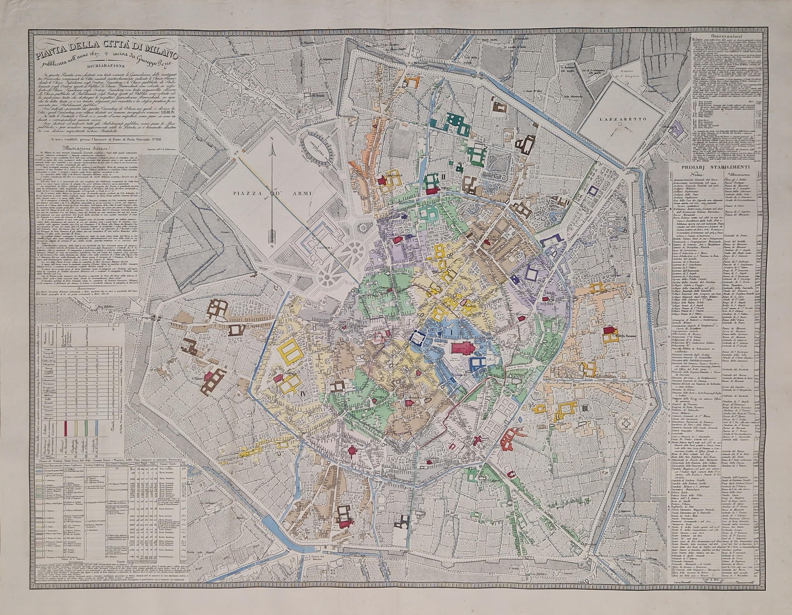
Pianta della cittá di Milano [Antique Plan of Milan, Italy]
Rare first edition of the plan of Milan, Italy, engraved in copper, printed and sold by Giuseppe Pezze in the same city in 1827.
Example finely hand-colored at the time, uncut.
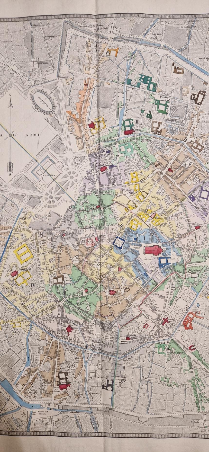
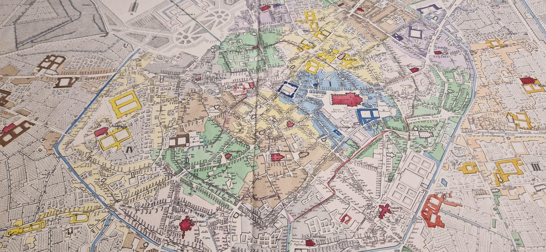
The peculiarity of the map is that it features the so-called Teresian house numbers, commissioned by Emperor Joseph II in 1786. This little intuitive system started from 1 at the Royal Palace (Palazzo Reale), then continued in a spiral towards the outskirts, reaching 4988 back towards the center in Contrada del Pesce, right behind the Canobbiana theater, next to the Royal Palace. We are offering the first edition of that map (1827); it was subsequently updated in 1844, 1847, 1856, 1860, and 1862.
Other features of the plan include the subdivision by color of the 24 parishes and the four police districts, as well as a series of general information regarding commercial activities and population, in addition to the list of "primary buildings" with their relative house numbers.
On the left and right sides, a series of information is reported, and in the cartouche, it reads: "In this map, the Jurisdictions of the twenty-four Parishes making up the City are distinguished with varied tints, with the Parish Churches, the Subsidiary Churches with the Subsidiary Oratories, and the public Churches of Establishments with Oratories open to the Public being particularly indicated. The Parish Churches are colored in strong red. The Subsidiary Churches with Subsidiary Oratories in light watercolor tint. The public Churches... are colored with the same tint that distinguishes the respective Parish Jurisdictions, except that the said tint is held somewhat more intensely there, and the same practice was observed for the Public Establishments. The perimeters of the 6 Police Districts (Mandamenti di Questura) into which the City is divided are indicated, and these Districts are also distinguished by Roman numerals I.II.III.IV.V.VI. In all the Streets and Alleys, the respective name is written, just as the corresponding house numbers are indicated. All public Establishments are distinguished and indicated, as are the public Weighing Stations, and to make the Map more useful, several important Statistical reports have also been illustrated."
Excellent condition.
-----------------------
Rara primera edición del mapa de Milán, Italia, grabado en cobre, impreso y vendido por Giuseppe Pezze en Milán en 1827.
Ejemplar finamente coloreado a mano en la época, sin cortar.
La particularidad del mapa es que presenta los llamados números de casa teresianos, encargados por el emperador José II en 1786. Este sistema, poco intuitivo, comenzaba con el número 1 en el Palacio Real (Palazzo Reale) y continuaba en espiral hacia la periferia, para terminar con el 4988 de nuevo hacia el centro, en la Contrada del Pesce, justo detrás del teatro de la Canobbiana, al lado del Palacio Real. Ofrecemos la primera edición de dicho mapa (1827); posteriormente fue actualizado en 1844, 1847, 1856, 1860 y 1862.
Otras características del plano incluyen la subdivisión por colores de las 24 parroquias y los cuatro distritos policiales, así como una serie de informaciones generales relativas a las actividades comerciales y la población, además del elenco de los "establecimientos principales" con su respectivo número de casa.
En los lados izquierdo y derecho se detalla una serie de informaciones, y en la cartela se lee: "En este mapa se distinguen con diversas tintas las Jurisdicciones de las veinticuatro Parroquias que componen la Ciudad, estando particularmente indicadas las Iglesias Parroquiales, las Iglesias Subsidiarias con los Oratorios Subsidiarios y las Iglesias públicas de Establecimientos con Oratorios abiertos al Público. Las Iglesias Parroquiales están coloreadas en rojo intenso. Las Iglesias Subsidiarias con Oratorios Subsidiarios en tinta de acuarela clara. Las Iglesias públicas... están coloreadas con la misma tinta que distingue a las respectivas Jurisdicciones Parroquiales, salvo que dicha tinta se aplica allí con algo más de intensidad, y la misma práctica se observó para los Establecimientos Públicos. Se indican los perímetros de los 6 Distritos Policiales (Mandamenti di Questura) en los que se divide la Ciudad, y estos Distritos se distinguen asimismo con números romanos I.II.III.IV.V.VI. En todas las Calles y Callejones se escribe el nombre respectivo, del mismo modo que se indican los números de casa correspondientes. Todos los Establecimientos públicos están diferenciados e indicados, al igual que las Estaciones de Pesaje públicas, y para que el Mapa sea más útil, también se han ilustrado diversos informes Estadísticos importantes".
Excelente estado de conservación.