Ethiopie
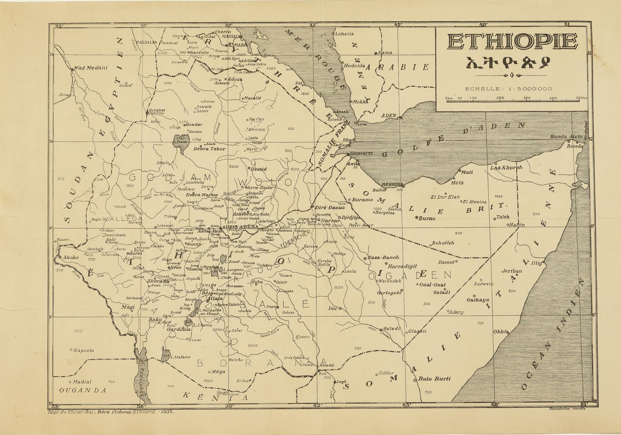
(43 x 30 cm, plate) This unrecorded map of Ethiopia, titled in both French (Ethiopie) and Amharic, was published in a remote village in the Sidama region, south of Addis Ababa, in 1935. It highlights the presence of Catholic missions in the country just months before the Italian invasion. Though predominantly Christian, Ethiopia was considered a land of missions by the Catholic Church. Around 1840, the Negus (Emperors) started tolerating their presence in peripheral regions, such as Harar, a Muslim city. In 1889, with the coronation of Menelik II, Catholic missionaries were officially authorized in the country, leading to the establishment of a network of stations and settlements by Lazarist and Capuchin orders. These missionaries gained significant influence, with a French Capuchin, Father Marie-Elie Jarosseau, becoming the primary tutor, then friend, of future Emperor Haile Selassie I. At the bottom of the map, the following inscription is visible: "Impr. du Christ-Roi; Béra (Sidamo) Ethiopie - 1935." This indicates the map was most likely printed in Bera Tedicho, a village a few miles south of Irgalem, where a French Catholic mission was established in 1931, probably by the Capuchin Order. In October 1936, the Sidama region was conquered by Italy. As a result of the hostilities, the mission station in Bera was destroyed and subsequently abandoned. The Bera mission station largely sank into obscurity and is rarely mentioned in available contemporary or modern sources. We were unable to trace any other publications from the Imprimerie du Christ-Roi or any texts printed in Bera during the 20th century. It is likely that the press was active for only a few months before its destruction in the conflict and the expulsion of the French missionaries by the Italian army. These missionaries were replaced by Italian counterparts, often from the same religious congregations, as missionary work was seen as a necessary ally to colonial powers, even by secular states. The printing press had been introduced to Ethiopia by French missionaries around 1905, making this map one of the earliest maps published in the country (we have found no record of earlier maps published in Ethiopia). When this map was created, Bera Tedicho had a population of about one hundred households. Given this context, the map is surprisingly well-drawn and well-produced. The bilingual title suggests that the press was capable of printing documents in both French/European languages and Amharic. The paper is thick, with a watermark reading "Registre A Launey," likely imported from France. The map depicts Ethiopia's river system, numerous cities, and the altitudes of several locations in meters. While the legend is missing, it appears that Catholic missionary settlements are marked on the map by a dot surrounded by a small circle, with major stations highlighted in bold. The map's content and the mention "Reproduction Interdite" (Reproduction Prohibited) at the bottom right suggest that th
Sin Encuadernar - No binding
Good (bueno)