| Referencia: | 05374 |
| Año: | 1656 |
| Lugar de edición: | Paris (40.6 x 53.3 cm) |
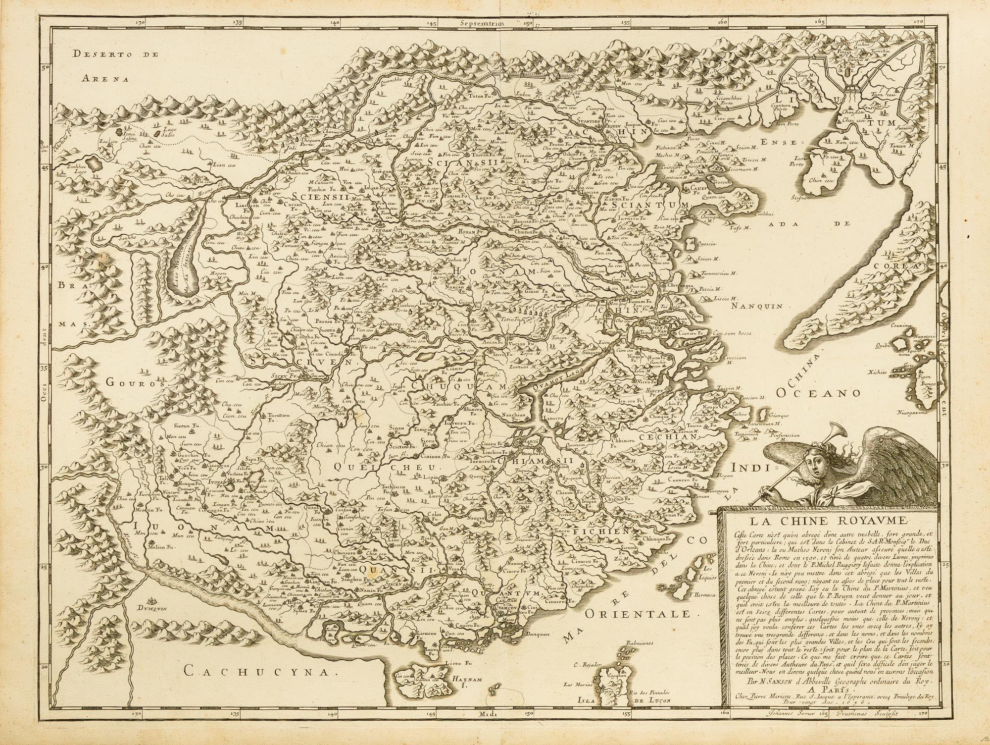
La Chine Royaume [Sanson map of China, 1656]
(41x53 cm) Early and scarce map of China and Korea, published in the important atlas Cartes générales de toutes les parties du monde in 1658, the first world atlas published in France. It is based on cartographic observations made by Jesuit missionaries Matteo Ricci, Michele Ruggieri, and particularly Martino Martini, considered an authority on Chinese territorial cartographic recording. The map includes the northern end of the Philippines and the Korean Peninsula with a curious elongated shape. It is worth noting that in maps of this era, Korea was traditionally represented as an island, so this map shows a very updated cartographic knowledge at an early stage. The Great Wall delineating the northern territory can also be observed. A cartouche in the lower right corner refers to the sources that Sanson used for the map's creation. Nicolas Sanson (1600-1667) was the most important French cartographer of the 17th century. He is even considered the father of the French school of cartography in its golden age, spanning from the mid-17th century to the mid-18th century. He began making maps in the 1620s, and in the following decade, he was already working with Melchior Tavernier. Later, Sanson collaborated with the publisher Pierre Mariette, with whom he published his grand atlas Cartes générales de toutes les parties du monde (1658). Throughout his career, he produced more than 300 maps, and upon his death in 1667, his son Guillaume continued the cartographic business in partnership with Alexis Hubert Jaillot, also becoming a renowned cartographer. -----------Muy temprano y escaso mapa de China y Corea, publicado en el importante atlas Cartes générales de toutes les parties du monde, en 1658, el primer atlas mundial publicado en Francia. Está basado en las observaciones cartográficas realizadas por los misionarios jesuitas Matteo Ricci, Michele Ruggieri, y particularmente Martino Martini, considerado una autoridad en materia de registro cartográfico del territorio chino. El mapa incluye el extremo norte de las Filipinas y la península de Corea con una curiosa forma alargada. Cabe señalar que en los mapas de esta época Corea era representada tradicionalmente como una isla, por lo que este mapa muestra de manera temprana un conocimiento cartográfico muy actualizado. Puede apreciarse también la Gran Muralla delimitando el norte del territorio. Una cartela en la esquina inferior derecha hace referencia a las fuentes que Sanson utilizó para la realización del mapa. Nicolas Sanson (1600-1667) fue el cartógrafo francés más importante del siglo XVII. Incluso es considerado el padre de la escuela francesa de cartografía en su época dorada, que abarcó de mediados del siglo XVII a mediados del siglo XVIII. Comenzó a hacer mapas en la década de 1620 y en el decenio siguiente ya trabajaba con Melchior Tavernier. Más tarde, Sanson trabajó con el editor Pierre Mariette, con quien publicó su gran atlas Cartes générales de toutes les parties du monde (1658). A lo la
No Binding
Very Good, Muy bueno.